Roads to Guadalupe.
addition to the three major pilgrimage sites in Christendom (Rome, Santiago and Jerusalem), there is another point that attracts pilgrims of old. For example in the Iberian Peninsula we have: Santo Toribio de Liebana, Caravaca de la Cruz, Fatima and Guadalupe.
some time, the proliferation new pilgrims and saturation for success, the French Way, has led the search for new routes. If we add the rise of walkers and cyclists who dare to do this, we recover and create new routes that releasing those old roads. My roots in Extremadura, a taste for travel paths and glens and the desire to enjoy spring in the oak forests of Extremadura, has led me to decide to do this route.
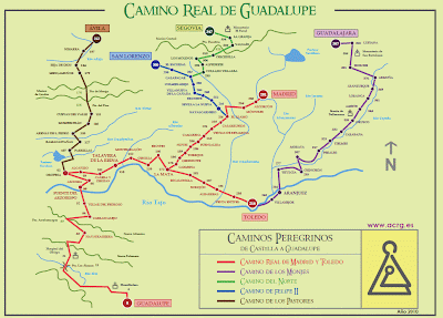
Guadalupe Road on the two sites that we should not miss:
- Itínere 1337. Project to highlight the value of historic roads Pilgrimage to the Monastery of Guadalupe, in collaboration with local action groups. To date is still in "infancy" but a good starting point.
- Association of Friends of the Camino Real de Guadalupe ACRG . Association has proposed to restore, preserve and promote the old Camino Real de Guadalupe. Feature on its website of a terrific road book (any attempt on my part to describe the course falls short of its level of detail) and are responsible for the white arrows that indicate the route. From here my gratitude for their selfless work.
My Way of Guadalupe.
Although from the Community of Madrid there is another possibility (you can attach Titulcia and Aranjuez, with the way from Toledo), I decided on the Camino Real from Madrid Retamosa Sales, Fuensalida and Torrijos.
Itínere itineraries ACRG 1337 and practically coincide except in the section from Calera and Huts to Puente del Arzobispo. Itínere path is diverted to pass through Oropesa.
not want to leave without commenting on the possibility of making the variant of the Camino de la Jara , Calera and Huts taking the Greenway Jara. Is planned for June 2011 end Villuercas Natural Way , joining the green path with Logrosán Jara, Guadalupe and connected with the Greenway Vegas del Guadiana.
Description.
The route begins in Madrid, taking as a starting point of the Jeronimos Church, through the city by some of its most emblematic (Puerta del Sol, Plaza Mayor, Royal Palace and Almudena Cathedral), and exit at the Casa de Campo. Following the road of Extremadura, Alcorcon, Mostoles we passed, to leave the metropolitan area by the Park of El Soto. Once in the Guadarrama River, will be our reference to the Alamo, close to where we left Madrid.
already in the province of Toledo, for the Sagra County, cross the plain of the Tagus, to reach the Tagus Vegas near its confluence with the Alberche. The route continues along the valley of the Tagus from Talavera de la Reina, the County Oropesa, to Puente del Arzobispo, leaving Toledo to enter Extremadura.
Duration: 3 days .
Total distance: 249.80 km (daily average 83.25 km).
accumulated Ascent: 2,151 m. (Daily average 717 m) .
pedaling Time: 18:26 (daily average 6:08).

01. Madrid-Torrijos.
Fecha: 31/03/2011 .
Dist.: 91.07 Km.; Asc.: 434 m; T. Tot.: 8:18; T. Mov.: 6:03.
Alt. Max.: 717 m; V. Med. Mov.: 14.06 km / h IBP.: 69CC .
H. Departure: 9:47 ; H. Arrival: 18:07 . Stage
quiet, with soft and good soil profile, with the only difficulty of the long mileage. Depending on the organization of the stages, you can shorten stopping at Las Ventas Retamosa or Fuensalida. Well-settled urban stretch (despite being surrounded by large roads do not step busy roads) to the Municipal Park of El Soto, to continue agricultural roads and cattle trails quiet.
For the first time in my ways begin in Madrid (on the road from Madrid started in Tres Cantos). I will not miss the opportunity to give me a walk downtown with the bike. Although the ideal is to leave the front door, I decided to take the commuter to Atocha and save me the wrong drink to get into Madrid. From the South Zone may bind to the pedaling Green Belt or connect with the way in Alcorcón ( A small green corridor). Although
start pedaling from the Glorieta de Atocha, next to the Reina Sofia Museum, the km 0 of the Camino Real de Guadalupe is in the Church of the Jeronimos. We went through some of the landmarks of Madrid: Prado Museum, House of Representatives, Puerta del Sol, Plaza Mayor, Church of Santiago (usual starting point of the Camino de Santiago from Madrid), Royal Palace and Cathedral la Almudena.
From La Almudena, the Cuesta de la Vega, descend to the River Manzanares next to the Puente de Segovia. To avoid traffic on the Paseo de Extremadura, I take the newly opened remodeling Manzanares and entered the House by the Puente del Rey. Links to the Path of GR Merino, which we follow the Casa de Campo. In part also matches the Green Belt cyclist. As a curiosity, I find the first white arrow crossing the Arroyo Meaques next to the zoo.
We left the House by the Puerta del Zarzón, entering the neighborhood of Camp. Among developments and barracks follow the Paseo de Extremadura (there is a section that moves along the path through it), and once the M-40 on the road to Venta la Rubia, we crossed by a pedestrian bridge in front of the Museum Air. For a small path is exceeded road junction (Paseo de Extremadura and A-5) and enters the roundabout Alcorcón San José de Valdez.
is only through Alcorcon, Mostoles to finally take the field for Parque de El Soto and enter Regional Park Middle Course Guadarrama River (from this point to the Alamo is still one of its paths, the Route 29). Good news, to the Guadarrama river is already operating the Greenway Almorox.
After crossing the Guadarrama river by the old iron bridge, continue along the valley by the Rail Toledano. Slice up the Stinger Bridge (Stone Bridge Road in Extremadura, completed in 1805 still in use, to save the River Guadarrama) is paved with a lot of traffic. This stretch of river is occupied by large numbers housing, which in my opinion should not be entirely legal. Following
Track Toledano, cross under the bridge of the new Radio 5, very near where the bridge was Zarzuela over Camino Real de Extremadura until the eighteenth century. A little later we left to come to the Alamo by Cord Casarrubios, where we entered the Hermitage of the Virgen de la Soledad.
From the Alamo, following the straight line from the ants, from Mount Casarrubios (has a nice roll of justice) leads to sales Retamosa The . Although all the way the track is good, reaching sales between Arroyo Vallehermoso and the bridge over the new motorway to Valmojado Illescas is a short stretch sandy.
At the end of Las Ventas Retamosa take the old road of Sales for about a mile, leaving him to follow a path parallel to the CM-4003 to Camarena. There is the possibility of further Fuensalida connecting directly to the Cañada Real Segovia (variant made by George and Sandra on your trip).
From Camarena, the Path of the Jewish Fuensalida is reached after crossing the Arroyo de la Venta de Palacio. There are some stretches that rain can be a real quagmire. In a short descent, rogue stone badly and suffer a slitting llantazo slime camera that I carry (which I have produced excellent results.) This will bring me a headache: several punctures in the normal camera and tried desperately to finish fixing the camera (the glue that holds expired and I can not repair the puncture). Fortunately I'm ahead and spare camera and glue.
Fuensalida Leaving the Camino de Novés connect with the Cañada Real Segoviana by which we arrive to Torrijos. The route makes a small detour to visit Novés , where we met with the Camino de Santiago Southeast.
Accommodation: Bar-Pension Grandpa. 15 €. Simple but comfortable room with shared bathroom. Recommended. Torrijos Arriving at a guy saw me with the bike and the saddle and thought he was doing the Camino de Santiago del Sureste. Very nice, I recommended the site, something Thank you very much. His reference 2 hotels, insurance much more expensive. Dinner menu 10 € at La Chaise Hotel Meson.
Other Lodging:
- The Alamo: Hostal El Alamo, tel 645897650 and Hosting Corner, Tel 918122685.
- Sales of Retamosa: Pension El Greco, Tel 918173515.
- Fuensalida: Hotel Fuensalida 2 * .
- Torrijos: 3 * Hotel Meson Castilla Hotel and 3 * .
02. Torrijos-Puente del Obispo.
Date: 01/04/2011 .
quiet, with soft and good soil profile, with the only difficulty of the long mileage. Depending on the organization of the stages, you can shorten stopping at Las Ventas Retamosa or Fuensalida. Well-settled urban stretch (despite being surrounded by large roads do not step busy roads) to the Municipal Park of El Soto, to continue agricultural roads and cattle trails quiet.
 |
| Church of the Jeronimos . 0 km |
For the first time in my ways begin in Madrid (on the road from Madrid started in Tres Cantos). I will not miss the opportunity to give me a walk downtown with the bike. Although the ideal is to leave the front door, I decided to take the commuter to Atocha and save me the wrong drink to get into Madrid. From the South Zone may bind to the pedaling Green Belt or connect with the way in Alcorcón ( A small green corridor). Although
start pedaling from the Glorieta de Atocha, next to the Reina Sofia Museum, the km 0 of the Camino Real de Guadalupe is in the Church of the Jeronimos. We went through some of the landmarks of Madrid: Prado Museum, House of Representatives, Puerta del Sol, Plaza Mayor, Church of Santiago (usual starting point of the Camino de Santiago from Madrid), Royal Palace and Cathedral la Almudena.
From La Almudena, the Cuesta de la Vega, descend to the River Manzanares next to the Puente de Segovia. To avoid traffic on the Paseo de Extremadura, I take the newly opened remodeling Manzanares and entered the House by the Puente del Rey. Links to the Path of GR Merino, which we follow the Casa de Campo. In part also matches the Green Belt cyclist. As a curiosity, I find the first white arrow crossing the Arroyo Meaques next to the zoo.
We left the House by the Puerta del Zarzón, entering the neighborhood of Camp. Among developments and barracks follow the Paseo de Extremadura (there is a section that moves along the path through it), and once the M-40 on the road to Venta la Rubia, we crossed by a pedestrian bridge in front of the Museum Air. For a small path is exceeded road junction (Paseo de Extremadura and A-5) and enters the roundabout Alcorcón San José de Valdez.
is only through Alcorcon, Mostoles to finally take the field for Parque de El Soto and enter Regional Park Middle Course Guadarrama River (from this point to the Alamo is still one of its paths, the Route 29). Good news, to the Guadarrama river is already operating the Greenway Almorox.
After crossing the Guadarrama river by the old iron bridge, continue along the valley by the Rail Toledano. Slice up the Stinger Bridge (Stone Bridge Road in Extremadura, completed in 1805 still in use, to save the River Guadarrama) is paved with a lot of traffic. This stretch of river is occupied by large numbers housing, which in my opinion should not be entirely legal. Following
Track Toledano, cross under the bridge of the new Radio 5, very near where the bridge was Zarzuela over Camino Real de Extremadura until the eighteenth century. A little later we left to come to the Alamo by Cord Casarrubios, where we entered the Hermitage of the Virgen de la Soledad.
From the Alamo, following the straight line from the ants, from Mount Casarrubios (has a nice roll of justice) leads to sales Retamosa The . Although all the way the track is good, reaching sales between Arroyo Vallehermoso and the bridge over the new motorway to Valmojado Illescas is a short stretch sandy.
At the end of Las Ventas Retamosa take the old road of Sales for about a mile, leaving him to follow a path parallel to the CM-4003 to Camarena. There is the possibility of further Fuensalida connecting directly to the Cañada Real Segovia (variant made by George and Sandra on your trip).
 |
| Jewish Berm between Camarena and Fuensalida |
From Camarena, the Path of the Jewish Fuensalida is reached after crossing the Arroyo de la Venta de Palacio. There are some stretches that rain can be a real quagmire. In a short descent, rogue stone badly and suffer a slitting llantazo slime camera that I carry (which I have produced excellent results.) This will bring me a headache: several punctures in the normal camera and tried desperately to finish fixing the camera (the glue that holds expired and I can not repair the puncture). Fortunately I'm ahead and spare camera and glue.
Fuensalida Leaving the Camino de Novés connect with the Cañada Real Segoviana by which we arrive to Torrijos. The route makes a small detour to visit Novés , where we met with the Camino de Santiago Southeast.
 |
| Collegiate Blessed Christ. Torrijos |
Accommodation: Bar-Pension Grandpa. 15 €. Simple but comfortable room with shared bathroom. Recommended. Torrijos Arriving at a guy saw me with the bike and the saddle and thought he was doing the Camino de Santiago del Sureste. Very nice, I recommended the site, something Thank you very much. His reference 2 hotels, insurance much more expensive. Dinner menu 10 € at La Chaise Hotel Meson.
Other Lodging:
- The Alamo: Hostal El Alamo, tel 645897650 and Hosting Corner, Tel 918122685.
- Sales of Retamosa: Pension El Greco, Tel 918173515.
- Fuensalida: Hotel Fuensalida 2 * .
- Torrijos: 3 * Hotel Meson Castilla Hotel and 3 * .
02. Torrijos-Puente del Obispo.
Date: 01/04/2011 .
Dist: 94.94 km ; Asc.: 254 m.; T. Tot.: 8:56; T. Mov.: 6:21.
H. Max.: 605 m.; V. Med Mov.: 14.03 km / h; IBP.: 65cc .
H. Departure: 8:48 ; H. Arrival: 17:48.
Like the previous stage with a smooth profile affordable largely flat but something long. The difficulty presents nearly 100 kilometers and the status of some of the tracks. We left the "pistorros" coming out of Madrid and pedals for a lane that is not more than two ruts. Besides the stretch-Montearagón Erustes has very sandy areas requiring foot cast to the ground and pushing.
The route leaves the road Torrijos CM-4009 (one of the few stretches where you are driving by car) to Gerindote . We return to earth following the Way of the Negrillos Which brings us back to the Cañada Real Segoviana , which we definitely striving toward Carmena on the Way to Carpio de Tajo (Follow the Arroyo de Alcabozo so during the rainy season we can find a pool of water) and the Camino Viejo de Carmena to Toledo.
is very close to La Mata where we arrived in the Way of Toledo. In La Mata connects the Kings Road branch is from Toledo (path by David Moreira and described in his blog MoreOcio ). We continue by asphalt (small road without traffic) to Erustes . Careful when crossing the railway line at Station Erustes (No pedestrian crossing). Cyclists can use a nearby overpass if they want to charge the bike.
begins in Erustes most problematic section of the day. El Camino and Cañada de Talavera Toledo takes Onion has large areas of sandy inciclable (although it seems incredible, the feeling that a truck has poured sand beach), especially when following the Arroyo de Arriba near Onion. They are just under 2 miles. At some point, but costs can pedal horrors. Montearagón Onion to track the road prevents CM-4000 (option for bikes). This road also has stretches of sand but shorter. Although in my opinion does not present too many problems there is a variant that avoids this section (described in the road book.)
After a short descent by road to the station cross the road Montearagón CM-4000 to continue along the road Cordel Onion ( lane between irrigation in some cases not more than two shot) between the Tagus and the same road. From here follow the signs to Talavera Road Tajo Natural GR 113. Framed within an ambitious Roads Program of the Ministry of Natural Environment Environment. For now only signaling but hopefully soon have more information.
When you get the confluence with the National V old, pass behind the Circle of Cazalegas Ships to the River Alberche you have to cross the bridge of the country. Warning, very dangerous stage, no shoulder and heavy traffic. The entrance to Talavera de la Reina is solved by a walk that runs parallel to the road, which becomes bike path passing through the city.
The times have I gone through Talavera and I never stopped to visit. This would be a good opportunity but took the decision to continue to Puente del Arzobispo and make three steps to Guadalupe. Two reasons: first, they weather the day after tomorrow and I want to ensure reaching Guadalupe and on the other, four stages to force me to stop at a house in Carrascalejo or Villar del Pedroso, so I have no insurance. There remains yet quietly back and visit Talavera.
Vega del Tajo Following a continuous track parallel to the CM-4101 road from Talavera to Puente del Arzobispo, through Alberche del Caudillo, to Calera and Huts . Well known among cyclists because from here starts the Greenway Jara, possible alternative to reach Guadalupe.
Leaving Calera and Huts on the Way to Alcañizo, sometimes in parallel with the railway, until we reach our second major cattle route of the day: East Leonesa Cañada Real. Here there is the possibility of a variant visiting Oropesa (Oropesa information-Bridge section of the Archbishop's blog Bikes in Pueblonuevo Miramonte). We continue along the Cañada Real that will be our reference to Puente del Arzobispo.
Before crossing the road Glen CM-4101 turn off on the Road to enter Valdeverdeja Tajo Alcolea and an asphalt track puts us in Puente del Arzobispo . A recommendation, if you have time to visit worth Interpretation Centre Ceramics.
Accommodation: Hostal Rural Los Pecos . 22 €. Room completely remodeled, spacious and with a good bed. The spectacular bathroom. Highly recommended, one of the best hostels I've found. Dinner menu (10 €) in the same place.
Other Lodging:
- La Mata: Hostal Concepcion .
- Onion: Hostal La Fragua .
- Talavera de la Reina, Talavera Hostel, Hostel Embassy and Pension Beach. More accommodation in Turismo Castilla-La Mancha .
- Calera and Huts: Hostel Cuatro Caminos.
H. Max.: 605 m.; V. Med Mov.: 14.03 km / h; IBP.: 65cc .
H. Departure: 8:48 ; H. Arrival: 17:48.
Like the previous stage with a smooth profile affordable largely flat but something long. The difficulty presents nearly 100 kilometers and the status of some of the tracks. We left the "pistorros" coming out of Madrid and pedals for a lane that is not more than two ruts. Besides the stretch-Montearagón Erustes has very sandy areas requiring foot cast to the ground and pushing.
The route leaves the road Torrijos CM-4009 (one of the few stretches where you are driving by car) to Gerindote . We return to earth following the Way of the Negrillos Which brings us back to the Cañada Real Segoviana , which we definitely striving toward Carmena on the Way to Carpio de Tajo (Follow the Arroyo de Alcabozo so during the rainy season we can find a pool of water) and the Camino Viejo de Carmena to Toledo.
 |
| Cañada Real Segoviana between Gerindote and Carmena |
is very close to La Mata where we arrived in the Way of Toledo. In La Mata connects the Kings Road branch is from Toledo (path by David Moreira and described in his blog MoreOcio ). We continue by asphalt (small road without traffic) to Erustes . Careful when crossing the railway line at Station Erustes (No pedestrian crossing). Cyclists can use a nearby overpass if they want to charge the bike.
begins in Erustes most problematic section of the day. El Camino and Cañada de Talavera Toledo takes Onion has large areas of sandy inciclable (although it seems incredible, the feeling that a truck has poured sand beach), especially when following the Arroyo de Arriba near Onion. They are just under 2 miles. At some point, but costs can pedal horrors. Montearagón Onion to track the road prevents CM-4000 (option for bikes). This road also has stretches of sand but shorter. Although in my opinion does not present too many problems there is a variant that avoids this section (described in the road book.)
 |
| Reaching | Onion
After a short descent by road to the station cross the road Montearagón CM-4000 to continue along the road Cordel Onion ( lane between irrigation in some cases not more than two shot) between the Tagus and the same road. From here follow the signs to Talavera Road Tajo Natural GR 113. Framed within an ambitious Roads Program of the Ministry of Natural Environment Environment. For now only signaling but hopefully soon have more information.
When you get the confluence with the National V old, pass behind the Circle of Cazalegas Ships to the River Alberche you have to cross the bridge of the country. Warning, very dangerous stage, no shoulder and heavy traffic. The entrance to Talavera de la Reina is solved by a walk that runs parallel to the road, which becomes bike path passing through the city.
 |
| Basilica of Our Lady Prado. Talavera |
The times have I gone through Talavera and I never stopped to visit. This would be a good opportunity but took the decision to continue to Puente del Arzobispo and make three steps to Guadalupe. Two reasons: first, they weather the day after tomorrow and I want to ensure reaching Guadalupe and on the other, four stages to force me to stop at a house in Carrascalejo or Villar del Pedroso, so I have no insurance. There remains yet quietly back and visit Talavera.
Vega del Tajo Following a continuous track parallel to the CM-4101 road from Talavera to Puente del Arzobispo, through Alberche del Caudillo, to Calera and Huts . Well known among cyclists because from here starts the Greenway Jara, possible alternative to reach Guadalupe.
 |
| El Mansur. Central System |
Leaving Calera and Huts on the Way to Alcañizo, sometimes in parallel with the railway, until we reach our second major cattle route of the day: East Leonesa Cañada Real. Here there is the possibility of a variant visiting Oropesa (Oropesa information-Bridge section of the Archbishop's blog Bikes in Pueblonuevo Miramonte). We continue along the Cañada Real that will be our reference to Puente del Arzobispo.
Before crossing the road Glen CM-4101 turn off on the Road to enter Valdeverdeja Tajo Alcolea and an asphalt track puts us in Puente del Arzobispo . A recommendation, if you have time to visit worth Interpretation Centre Ceramics.
 |
Accommodation: Hostal Rural Los Pecos . 22 €. Room completely remodeled, spacious and with a good bed. The spectacular bathroom. Highly recommended, one of the best hostels I've found. Dinner menu (10 €) in the same place.
Other Lodging:
- La Mata: Hostal Concepcion .
- Onion: Hostal La Fragua .
- Talavera de la Reina, Talavera Hostel, Hostel Embassy and Pension Beach. More accommodation in Turismo Castilla-La Mancha .
- Calera and Huts: Hostel Cuatro Caminos.
03. Archbishop-Guadalupe Bridge.
Date: 02/04/2011 .
Dist: 63.69 km ; Asc.: 1,463 m.; T. Tot.: 8:34; T. Mov.: 6:02.
H. Max.: 1,085 m.; V. Med Mov.: 9.03 km / h; IBP.: 111AB.
H. Output: 8:47; H. Arrival: 17:24 .
very hard stage, with 1,700 meters of ascent in just over 60 miles and 6:30 pedaling. Starts rising from Puente del Arzobispo, to face two very tough ports (Arrebatacapas and Collado's Hospital) and end the Loma del Caballo. It also has sections trial bike trail (down Arrebatacapas and Puerto del Hospital), areas with strong hard and harsh ramps (up to Arrebatacapas, bordering the Finca Las Lucia firewall in the Sierra del Hospital and Arroyo Pinarejos) that binds at times, to take the foot down and push the bike.
My advice for cyclists "quiet" is to avoid the more difficult parts and complicated road cycling since Carrascalejo according to the Chapel of the Shrine. First by DC-20, to overcome Arrebatacapas ports and Hospital, and then the EX-118 (may have more traffic) to the Hermitage of Shrine. The descent can be done Guadalupe avoiding asphalt, easy path to good firm.
seems that weather forecasts are confirmed and after two sunny days Today the clouds will gain the sun, fortunately the rain did not make an appearance and the temperature is pretty good. At the end of Puente del Arzobispo, enter Extremadura - Villuercas Commonwealth, and La Jara Ibor - across the medieval bridge built by the Archbishop Pedro Tenorio in 1388.
follow the Cañada Real Leonesa East occupied by the EX-387 road (traffic) can even be circular largely beyond the asphalt (as each one). On arrival at Cerro de la Cheese leave the road (you can continue it until Villar del Pedroso) to between Glen oaks real continue for just over a mile, leaving definitely go towards the Villar del Pedroso Camino de las Rosas. A small high-crowned Canchales of Navalcarreta, "for good track descend to the road of the Villar del Pedroso (paved) and come to Villar del Pedroso.
output A Villar del Pedroso, by the Way of the gardens, I get the big surprise to find the signaling of GR Tajo Natural Way 113, which continue to near the Laguna de la Dehesa arrival the Road to Valdeverdeja Carrascalejo. We turn left to enter Carrascalejo .
Carrascalejo starts in the first of the ports hard day, the Sierra de Altamira port Arrebatacapas (3 km and 300 m of ascent), the track of the losses to connect with the road leading to the port. The track climbs the Cuesta Colorada the gorge formed by the Slaty Creek. Very hard climb up the road (average gradient 10%), the hardest part is the end (about 500 meters to 16 % And bad sign). After that 5% of the road seems a walk.
Arrebatacapas Harbor part a small trail (marked with white arrows) which falls the shadow of the Risco of Banderillas to the Port of Sale. A first tranche impracticable for bikes zeta prevents the road. After crossing, the trail continues in steep decline, which is closed by the thickets and rocky tight enough (sections on foot). When you reach a more open area is better to continue down to the track that climbs to the Port of the Sale and leads to Navatrasierra .
We left the road Navatrasierra CC-20 (lanes there is a shortcut for avoiding a pair of curved plate 35 Km . to Guadalupe) in a short descent to cross the river Gualija, which starts the second port of the day, the hill's Hospital ( 10 km and 480 m ascent) which crosses the Sierra de la Palomera. Much is made on the road (traffic virtually non-existent) but there are three variants that prevent the asphalt.
The first near the Place de Robledillo, next to Bed The Lucia. We left the road on a track that borders the property passing several gates. Upon reaching the last, I find which way to go, and from the house I tell you how. We must continue parallel to the fence, between barely jaral path to go back to the road (walking leg). Bikes do not really worthwhile.
Soon after, the second, once the tightness of Tumbafrailes Chorrera. The Bridge recreational area Horcones part one track (the starting point of the walking trail by the Sierra de la Palomera) than ascent through pine leads to a firewall (about 650, average gradient of 11%, I do walk) just leaving back to the road.
After winning a high altitude, again on the road, bordered the Cerro del Carbonero to go down the Valley Hospital del Obispo. Hospital hamlet near Bishop, the last, a beautiful oak forest access track between the port avoiding the final turns of the road.
On the descent from the hospital door to the Port of Cubero have to be very careful because it is a difficult stretch orientation. Port partly a clear track in a westerly direction we left 70 meters with a less evident in the south-southeast, and just getting lost among the thickets to become trail. Important not to take the first path on the right coming down the slope abruptly, we must go straight to descend slowly (but fun technical section) to the Port of Cubero where we left off the road.
decline Ahead "glorious", fast track and good (possibly the only travel) to a diversion marked (May be taken as a reference power line) that lowers the Pinarejos Arroyo, who will cross a small bridge in a lovely spot. A tough but short steep slope (500 m to 13%) puts us in the Los Alamos bridge over the river Ibor.
very hard stage, with 1,700 meters of ascent in just over 60 miles and 6:30 pedaling. Starts rising from Puente del Arzobispo, to face two very tough ports (Arrebatacapas and Collado's Hospital) and end the Loma del Caballo. It also has sections trial bike trail (down Arrebatacapas and Puerto del Hospital), areas with strong hard and harsh ramps (up to Arrebatacapas, bordering the Finca Las Lucia firewall in the Sierra del Hospital and Arroyo Pinarejos) that binds at times, to take the foot down and push the bike.
My advice for cyclists "quiet" is to avoid the more difficult parts and complicated road cycling since Carrascalejo according to the Chapel of the Shrine. First by DC-20, to overcome Arrebatacapas ports and Hospital, and then the EX-118 (may have more traffic) to the Hermitage of Shrine. The descent can be done Guadalupe avoiding asphalt, easy path to good firm.
seems that weather forecasts are confirmed and after two sunny days Today the clouds will gain the sun, fortunately the rain did not make an appearance and the temperature is pretty good. At the end of Puente del Arzobispo, enter Extremadura - Villuercas Commonwealth, and La Jara Ibor - across the medieval bridge built by the Archbishop Pedro Tenorio in 1388.
 |
| Villar del Pedroso and Sierra de Altamira |
follow the Cañada Real Leonesa East occupied by the EX-387 road (traffic) can even be circular largely beyond the asphalt (as each one). On arrival at Cerro de la Cheese leave the road (you can continue it until Villar del Pedroso) to between Glen oaks real continue for just over a mile, leaving definitely go towards the Villar del Pedroso Camino de las Rosas. A small high-crowned Canchales of Navalcarreta, "for good track descend to the road of the Villar del Pedroso (paved) and come to Villar del Pedroso.
output A Villar del Pedroso, by the Way of the gardens, I get the big surprise to find the signaling of GR Tajo Natural Way 113, which continue to near the Laguna de la Dehesa arrival the Road to Valdeverdeja Carrascalejo. We turn left to enter Carrascalejo .
 |
| Villar del Pedroso and Carrascalejo from the Sierra de Altamira |
Carrascalejo starts in the first of the ports hard day, the Sierra de Altamira port Arrebatacapas (3 km and 300 m of ascent), the track of the losses to connect with the road leading to the port. The track climbs the Cuesta Colorada the gorge formed by the Slaty Creek. Very hard climb up the road (average gradient 10%), the hardest part is the end (about 500 meters to 16 % And bad sign). After that 5% of the road seems a walk.
 |
| Port |
Arrebatacapas Harbor part a small trail (marked with white arrows) which falls the shadow of the Risco of Banderillas to the Port of Sale. A first tranche impracticable for bikes zeta prevents the road. After crossing, the trail continues in steep decline, which is closed by the thickets and rocky tight enough (sections on foot). When you reach a more open area is better to continue down to the track that climbs to the Port of the Sale and leads to Navatrasierra .
 |
| Path Arrebatacapas losing |
We left the road Navatrasierra CC-20 (lanes there is a shortcut for avoiding a pair of curved plate 35 Km . to Guadalupe) in a short descent to cross the river Gualija, which starts the second port of the day, the hill's Hospital ( 10 km and 480 m ascent) which crosses the Sierra de la Palomera. Much is made on the road (traffic virtually non-existent) but there are three variants that prevent the asphalt.
The first near the Place de Robledillo, next to Bed The Lucia. We left the road on a track that borders the property passing several gates. Upon reaching the last, I find which way to go, and from the house I tell you how. We must continue parallel to the fence, between barely jaral path to go back to the road (walking leg). Bikes do not really worthwhile.
 |
| Going to Puerto del Hospital |
Soon after, the second, once the tightness of Tumbafrailes Chorrera. The Bridge recreational area Horcones part one track (the starting point of the walking trail by the Sierra de la Palomera) than ascent through pine leads to a firewall (about 650, average gradient of 11%, I do walk) just leaving back to the road.
After winning a high altitude, again on the road, bordered the Cerro del Carbonero to go down the Valley Hospital del Obispo. Hospital hamlet near Bishop, the last, a beautiful oak forest access track between the port avoiding the final turns of the road.
On the descent from the hospital door to the Port of Cubero have to be very careful because it is a difficult stretch orientation. Port partly a clear track in a westerly direction we left 70 meters with a less evident in the south-southeast, and just getting lost among the thickets to become trail. Important not to take the first path on the right coming down the slope abruptly, we must go straight to descend slowly (but fun technical section) to the Port of Cubero where we left off the road.
 |
| Descent from the Puerto del Hospital |
decline Ahead "glorious", fast track and good (possibly the only travel) to a diversion marked (May be taken as a reference power line) that lowers the Pinarejos Arroyo, who will cross a small bridge in a lovely spot. A tough but short steep slope (500 m to 13%) puts us in the Los Alamos bridge over the river Ibor.
After crossing the bridge, starts the final climb of the day in the path of Horse Race (4 kilometers and 180 meters of climb) by Ibor river valley and the foothills of Sierra de Guadalupe. Although track with good firm and smooth, the accumulated fatigue makes it pretty hard.
 | Hermitage
The track ends at a roundabout next to the Chapel of the Shrine. Although you can down the road, a footpath (marked and recovered by "elders" of Guadalupe) avoids the following asphalt beneath it. The steady, firm and good views Guadalupe, make it very desirable, entering the monastery through the Arco de San Pedro.
 |
Lodging: Hostal Cerezo I . 22 €. Simple but comfortable. Extremely courteous. In Guadeloupe there are plenty of hostels, many of them in the same town. This is about 80 meters. To keep things simple was the first to ask. As closing time approached, directly left the bike and prepared to visit the monastery. Highly recommended tour (4 €). Apart from sightseeing, accompanied by the monks can go to the chapel of the Virgin of Guadalupe.
Other Accommodations:
- Oropesa: Hostal La Plata Hostal and Inn.
- Villar del Pedroso: Casa Rural El Pedroso.
- Carrascalejo: Rustic Bungalows (Mercedes Alvarez, C / Isabel Monje 1, 927555058-927555163) and house La Casa del Practitioner.
- Navatrasierra: Mercedes Barbado Montero (Avenida de Guadalupe 4, Tel 927 556 521) and The Lucias Bed (5 km off-route).
- Guadeloupe: There are many hostels and hotels, you can consult the Tourist Office .
0 comments:
Post a Comment